GIS & Drone Services
We apply technology to improve project outcomes and solve environmental problems. Geospatial and remote sensing services can accompany active restoration projects to answer environmental questions. With trained GIS technicians and licensed drone pilots on staff, we can collect, analyze, and interpret a variety of geospatial data sets.
Geospatial Data Collection
With field crews and data technicians equipped with tablets and high accuracy GPS receivers, we can collect a diverse array of datasets from the ground or simply help track on-going work. With data collected by our staff or provided by our clients we conduct statistical analyses to answer complex questions. By applying technology and proper data collection techniques, we can convey complex information and data through informative maps that help clients plan and communicate with stakeholders.
Aerial Imagery Capture
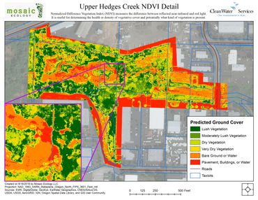
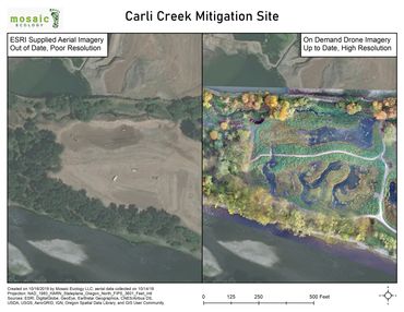
We capture the most up-to-date imagery of project areas to help our clients understand ground conditions in real time. We can help you monitor your project progress, with high resolution before, during and after imagery. Our aerial imagery helps clients locate potential hazards and opportunities not readily visible from the ground or on low resolution, out of date internet imagery. Using a multispectral camera, Normalized Difference Vegetation Indexes are generated to detect vegetation coverage and determine relative vegetation health or stress.
Digital Terrain and 3D Models
We can create digital spatial models from still images and videos to generate precise elevation and terrain models, perfect for determining high and low ground, likely drainage routes, and tree heights. Combined with aerial imagery and vegetation index, this can be an incredibly effective tool to delineate areas where potential native plant communities would best thrive following the removal of invasive monocultures.
Videography and Promotional Materials
Our high-quality video flights and aerial still imagery can be used for promotional materials, during presentations, and on websites to help communicate project success and progress to less technically minded stakeholders, and to elicit community interest and investment in projects.
Check out the Mosaic Ecology YouTube channel for some example video.
SERVICES
- GPS Data Collection
- Vector & Raster Analysis
- Orthomosaic Photography
- NDVI Analysis
- Canopy Analyses
- Aerial Cinematography
- Database Management
- General Data Collection
- DEM Generation
- Data Analysis
- Banding
- Near-Infrared Collection
Maps
.jpg/:/cr=t:0%25,l:0%25,w:100%25,h:100%25/rs=w:370,cg:true)